Select Page

Horseshoe Canyon

Canyonlands National Park

Spectacular Rock Art

Horseshoe Canyon was added to Canyonlands National Park in 1971 to preserve one of the finest ancient rock art sites in North America – the Great Gallery. This stunning Barrier Canyon style pictograph panel has magnificent life-size painted figures, many decorated with intricate designs.

Plan Your Visit

Accessing the Horseshoe Canyon rock art site includes a 30-mile (48 km) drive in on a graded unpaved road, and a 7-mile (11.2 km) round trip hike, but it is well worth the effort.

Because this a remote area, make sure to take all the water you will need, some snacks, and extra clothes in case of unexpected weather.

Spring and Fall are the best seasons to visit, when temperatures are more moderate.

Directions

Most visitors access Horseshoe Canyon from UT Highway 24.

From I-70 West of Green River, UT, take the UT Highway 24 exit. Drive south on Utah Highway 24 for about 24 miles (38.6 km) until you see the sign and turn off for Goblin Valley on your right (west). Continue 3 more miles to a signed turn on the left (east) onto the unpaved road. Follow signs to the trailhead. Driving time is roughly 2.5 hours from Moab or 1.5 hours from Green River, UT.

The road is usually drivable by two-wheel-drive vehicles, but precipitation or shifting sand may make 4-wheel drive necessary. Check the road conditions page, or call ahead: (435) 259-2652, from 8 am to 4:30 pm Mountain Time (Please do not call this number between 5 pm and 8 am except for Maze-area emergencies).
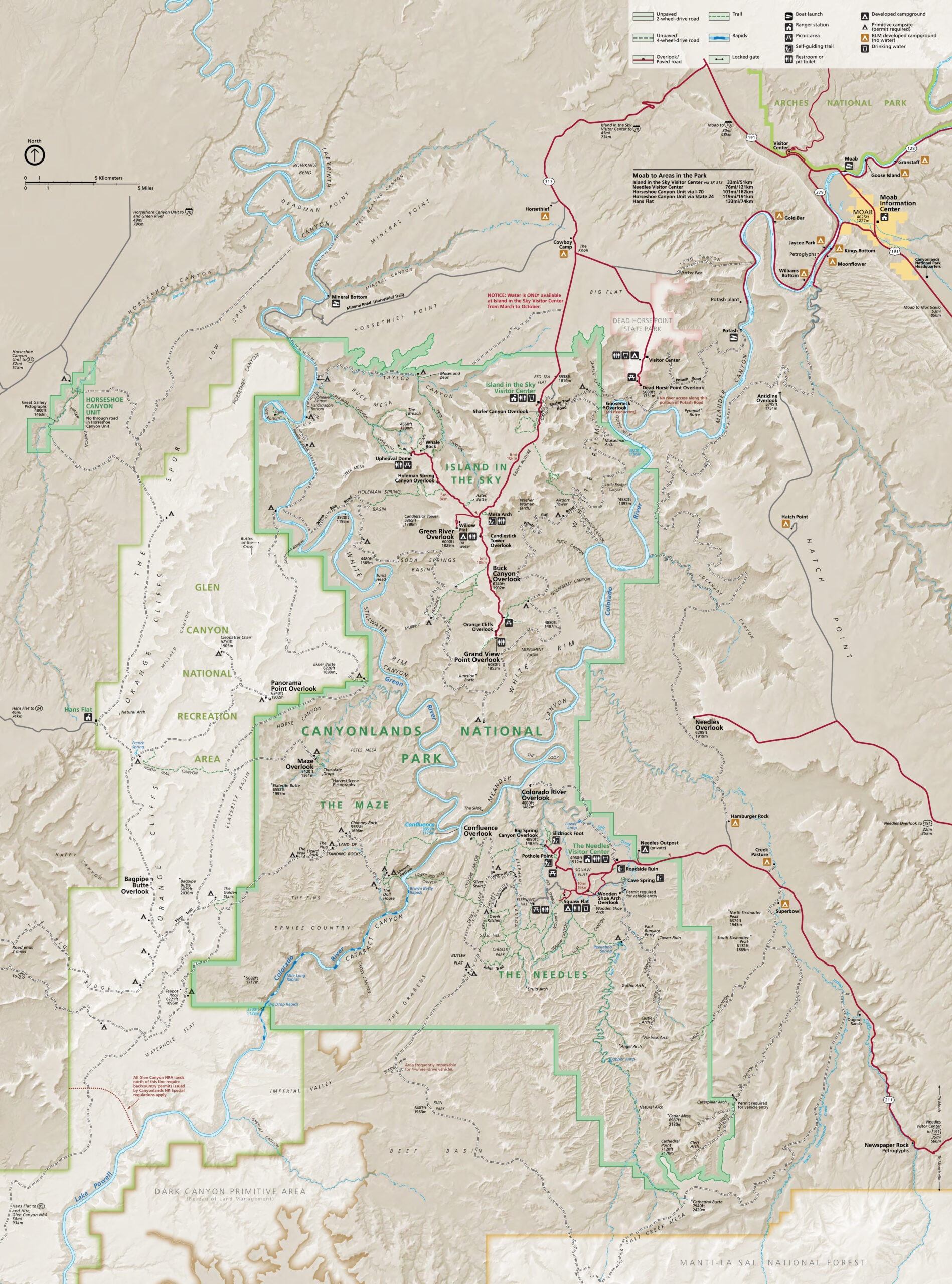
Park Map

The official park map shows all the roads and trails in Canyonlands National Park. You will receive a copy when entering the park (if the fee booth or visitor center is open). The map can also be downloaded from NPS.gov, or you can purchase a copy of the park brochure that includes the map at the Island in the Sky Visitor Center, the Moab Information Center, or from CNHA’s web store.

Things to Know

  • Do not rely on a GPS unit to guide you to Horseshoe Canyon. Use a map instead.
  • Pets are prohibited on the trail or below the rim of Horseshoe Canyon.
  • Please do not touch the rock art. Leave artifacts where you find them.

Things You Might Need

Your purchases and donations support education and research on the public lands of Southeastern Utah!

Shop Now

Page - Visit Canyonlands - The Maze

  • Canyonlands The Needles District Hand-Painted Glass Ornament Canyonlands The Needles District Hand-Painted Glass Ornament $22.99
    You'll treasure this beautiful glass ornament! The colorful Needles in Canyonlands National Park are hand-painted on the front, and famous Mesa Arch is on the other side. Comes in a keepsake padded box and built-in hanger. Size: 2.75 inches in diameter #4707
  • Canyonlands Geometric Design T-Shirt Canyonlands Geometric Design T-Shirt $29.99 - $32.99
    If you've enjoyed the endless views from Canyonlands Island in the Sky, you'll love this soft, light stylized design t-shirt by Wild Tribute. Wild Tribute donates 4% of all proceeds to our national parks and public lands! Material: 60% Cotton, 40% Poly blend
  • Canyonlands Maze District Map Canyonlands Maze District Map $11.95
    Of the four districts in Canyonlands National Park, the Maze District is the least accessible and requires planning and time to explore its remote landscapes. This map of Maze District provides an unparalleled tool for exploring this extraordinary region. Key areas of interest featured on this map include Colorado and Green rivers; Cataract, Stillwater, and Horseshoe canyons; Land of Standing Rocks; Orange Cliffs; and a large portion of the adjacent Glen Canyon National Recreation Area. Other features found on this map include: Canyonlands National Park, Glen Canyon National Recreation Area, Green River, Soda Springs Basin. The map base includes contour lines and elevations for summits. Trails and roads include mileage between intersections, and river mileage is noted as well for those exploring by boat. Road types are differentiated so you know if the route you choose is a four-wheel-drive or high-clearance road. Mountain bike routes are color-coded according to difficulty. Handy trail and backcountry road summaries, and helpful information about backcountry safety, regulations, and permits is included as well. Recreation features are clearly marked, including campgrounds, picnic areas, points of interest, boat launches, and scenic overlooks. Trails Illustrated map #312. Scale: 1:35,000. Waterproof, tear-resistant, topographic map. #3183
  • Canyonlands National Park Lapel Pin Set Canyonlands National Park Lapel Pin Set $24.99
    This beautiful four piece pin set, includes Island in the Sky, The Needles, The Maze, and Mesa Arch, all located in Canyonlands National Park. Hard enamel pins w/ nickel finish; rubber pin back Size: Each lapel pin is 1.25 x .75 inches #4970
  • Canyonlands International Dark Sky Poster Canyonlands International Dark Sky Poster $14.99
    "Half the park is after dark." Celebrate Canyonlands National Park's 2015 designation as an International Dark Sky Park! The International Dark-Sky Association (IDA) has granted Gold-Tier International Dark Sky Park status to Canyonlands National Park, an honor reserved for the darkest of dark skies and the most stunning of stars capes. Illustration by Tyler Nordgren. Poster is rolled for shipping. Size: 12 x 18 inches #4100